The Terrible T's: Turbulence, Thunderstorms, & Tornadoes
By James Williams
Reprinted with permission from FAA Safety Briefing
Whether or not you are a parent, you have no doubt witnessed some toddler’s force-of nature temper tantrum. It’s actually quite amazing to see how quickly a sweet little person can spin into a stomping, shrieking, swirling mass of destructive energy.
Mother Nature is capable of a similar metamorphosis, shifting from serene to stormy in surprisingly short order. Though her fury mimics the “Terrible Twos,” Mother Nature’s version takes the form of the Terrible Ts: turbulence, thunderstorms, and tornadoes. As I learned from many years spent in Florida, all three can unleash enormous amounts of destructive energy that is perilous for pilots and their planes.
Unlike parents, pilots do not enjoy the option of sending the miscreant to a corner for time out. Since we are the ones obliged to take time out, it behooves us to accurately read the signs of an approaching meteorological meltdown and take cover until the fury of Mother Nature’s Terrible Ts subsides.
Things that Go Bump in the Flight
Turbulence varies significantly, ranging from minor nuisance to wing-shearing intensity. Avoidance of the worst conditions requires awareness of the sources of turbulence which, like other weather conditions, often arise from a variety of disruptions and imbalances. Let’s take a look.
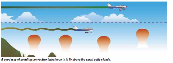
All pilots are familiar with the tamer varieties of bumpy air, and I quickly learned that it was not possible to fly in Florida without becoming accustomed to being bounced by the ubiquitous pockets of rising air. In Florida, as in similar areas, the mixture of surfaces includes roofs, open grass, water, trees and, of course, pavement. All absorb and radiate heat at different rates, resulting in varying levels of rising air and the rows of small puffy clouds that are a trademark of Florida afternoons. Those clouds are a good indicator to pilots of a ride that is likely to feel a lot like driving down a bumpy, well rutted road.
Shifting winds aloft are another turbulence generator, potentially more dangerous than the bumps under so-called fair weather cumulus. If your weather briefing shows that winds aloft vary more than 90 degrees in direction, or if there are significant changes in velocity from one reporting altitude to the next, you can expect to experience turbulence at the boundary where those differing conditions collide.
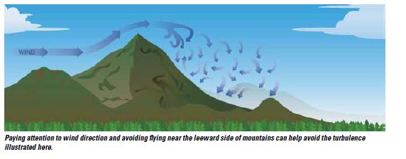
A third source of turbulence, one pilots must note and carefully accommodate, is the movement of air over and around man-made or natural obstacles. This level of such turbulence usually depends on the size of the obstacle and the amount of air moving over/around it. Logically enough, the level of such turbulence will intensify with any increase in wind speed. The size of the obstacle has an effect as well: Both the intensity and the size of the turbulence field on the leeward side are higher with larger obstacles, such as mountains.
Even if there is not enough moisture to create the lenticular clouds that are the surest signpost of this turbulence, you can “see” it by visualizing the rapid flow of water over and around rocks in a stream. Like water flowing over rocks, the air flow over an obstacle such as a mountain is smooth on the windward side. As it clears the obstruction, however, the flow becomes turbulent. That alone is bad enough, but it can be deadly when it occurs in areas of rising terrain. As noted in Rocky Mountain High that’s why mountain flying experts recommend special training before you attempt to operate in this environment.
A Towering Rage
When retreating glaciers formed the generally flat expanse of the Midwest and Great Plains, they didn’t just leave fertile farm land in their wake. They created a perfect stage to funnel cold dry air from the north into warm moist air from the Gulf of Mexico. That’s why the United States has the dubious distinction of being a world leader in the number and intensity of severe thunderstorms.
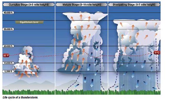
Let’s review the life cycle of a typical thunderstorm. Thunderstorms start life as happy and often harmless-looking cumulus clouds, giving rise to the term “cumulus stage.” Though many stop there, ingredients such as heat, moisture, and instability (i.e., tendency of air to rise) are a recipe for a truly Terrible T – the thunderstorm.
When the atmosphere is unstable, as can happen during frontal movement, the puffy, happy little cloud climbs further and further into the sky. Small updrafts start combining to form the large updrafts that lift the cloud, along with all its moisture, into the upper atmosphere. The harmless cumulus cloud becomes a dark and threatening cumulonimbus, noted in weather abbreviations as “CB.”
When the cloud can no longer support the weight of its accumulated moisture, that moisture begins to fall as rain or, if temperatures are sufficiently low, as hail. This stage, called the “mature” phase, is the most violent point of the storm because there is a violent and unpredictable combination of updrafts and downdrafts.
Non-aviators often assume the danger in a thunderstorm is lightning, but pilots know that thunderstorm-level turbulence is the real killer. No airplane, least of all a light GA aircraft, is designed to withstand such stress.
The storm reaches its dissipating stage at the point where downdrafts outnumber updrafts. Like a toddler whose fury has finally exhausted the ready supply of tears and energy, the thunderstorm literally rains out its energy and begins to subside.
A word about lightning: Lightning is created by an imbalance in the electrical charge between the ground and the clouds. Thunder is the sound made by the rapidly expanding air super heated by a lightning bolt – which is hot enough to turn sand into glass. Aircraft are built to absorb and dissipate lightning, which follows the path of least resistance to the ground. By design, that path is usually the metal skin of the aircraft or the protection systems built into composite aircraft. Still, it’s a good idea to avoid situations that would expose your aircraft to lightning … especially since lightning lurks in the same neighborhood as the big bully cumulonimbus. As you probably remember, the FAA recommends keeping at least 20 nautical miles from these storms.
The Vicious Vortex
A tornado, one of the most intense manifestations of extreme weather, is also one of the most destructive forces of nature. Because tornadoes are usually generated by massive severe thunderstorms, the United States again tops the charts in terms of the number and severity of tornadoes it experiences in any given year. In fact, the high incidences of tornadoes in certain parts of the country have given a large swath of land from Texas to the Dakotas the “Tornado Alley” nickname. Another clue is the location of the National Weather Service Storm Prediction Center in Norman, Oklahoma.
Let’s start with the basics. A tornado is a spinning column of high winds that descend from the base of a cloud to the surface of the earth. Usually, but not always, a tornado has a condensate cloud appearance that makes it more visible.
Many reports put the top wind speed of the most powerful tornados at above 300 mph. The severity of a tornado is defined by the Enhanced Fujita Scale (EF), with wind speeds calculated on the basis of how much damage was done. The scale ranges from EF-0 on the low end to EF-5 on the high end. An EF-0 tornado has winds between 65 and 85 mph and generally only damages trees and non-permanent structures. On the high end, EF-5 tornadoes have wind speeds exceeding 200 mph and can obliterate virtually any structure short of a concrete bunker.
Just to be clear, though: Every tornado is a vicious vortex capable of wreaking havoc with life and property. If you happened to be in Lakeland for Sun ‘n Fun 2011, you will have a clear memory of the tornado, along with an appreciation for the damage that even an EF-0 can do.
By now it should also be clear that there are no real strategies for dealing with a tornado other than avoiding them at all costs. The best idea is to avoid thunderstorms by a wide margin, which should also allow you to avoid encountering a tornado. And with respect to preparations on the ground, the best thing you can do is to secure your aircraft and find safe shelter for yourself. Your aircraft can be replaced.
Just as parents hope to avoid the tantrums of the toddler’s Terrible Twos, pilots hope to evade the fury of Mother Nature’s Terrible Ts. Take time out to be sure your avoidance strategies are in place before you need them.
James Williams is FAA Safety Briefing’s assistant editor and photo editor. He is also a pilot and ground instructor.
|