Fearsomely Foul
Dealing with Fog, Freezing Precip, and other Nasties from the North
By Tom Hoffmann
Reprinted with permission from FAA Safety Briefing
When it comes to weather extremes in the northern part of the United States, there’s a lot to consider. While headline-grabbing hurricanes and tornadoes aren’t completely out of the question in some areas, it’s often the more elusive variety of winter weather hazards that gives pause to a pilot’s flight plans. In the north, pilots must deal with such perils as blinding fog, blowing snow, freezing rain, and ice-laden clouds, not to mention the treacherous terrain often lurking behind the veil of these icy dangers. Unplanned encounters with any of these conditions can spell disaster faster than you can say Jack Frost.
The key to being prepared for these hazards relies largely on understanding how and why they develop. Despite the wide range of environments found in the north, there are many common factors at play in determining weather. Among them are wind, moisture and topography, all of which intertwine in different ways to give each area of the north its own unique flavor of weather patterns and idiosyncrasies. From the constant onshore flow of moisture in the Pacific Northwest, to the frigid and blustery conditions of the Great Plains, there’s definitely no shortage of winter weather phenomena that can impact flying safety. And while no region is off limits to another’s more prevalent dangers, understanding the microclimatic conditions predominant in your neck of the woods will go a long way in keeping you prepared for whatever Mother Nature dishes out.
Some Wicked Harsh Weather
A pilot unprepared for a run-in with New England winter weather can be as terrified as a baseball rookie facing Fenway Park’s infamous Green Monster for the first time. Confronted with the left field wall’s quirky dimensions, a player must quickly develop a strategy—both offensive and defensive—to not get caught off guard and have a better chance of success.
A similar approach would be well advised to a pilot facing the mixed bag of wintry precipitation all too common in the Northeast. Proactive strategies are a must since almost every type of extreme weather can occur in this area – blizzards, severe cold snaps, icing, and high winds. It’s a buffet of all things ice and snow, but one which pilots would certainly find unappetizing.
So what makes New England weather so unique? For starters, the topography of the region has a tremendous influence on how weather forms. Upper-level low pressure systems from the west and the south commonly converge in a coastal stretch surrounded by mountains on one side, and moist ocean air on the other. In the winter, this means prime conditions for Instrument Meteorological Conditions (IMC) and icing. When you mix that with the region’s challenging mountainous terrain, risk factors can quickly skyrocket, demanding a pilot’s tight grip on situational awareness.
Moving slightly more west brings another influential winter weather factor into the mix: the Great Lakes. Cold, dry air drifting over the Great Lakes can pick up large amounts of moisture and then deposit it on the surrounding land areas in the form of lake effect snow. This Midwest phenomenon creates some of the heaviest annual snowfall rates in the country. According to a study by NOAA’s National Climatic Data Center (NCDC), the towns of Marquette and Sault Ste. Marie, Mich., were among the top five snowiest cities over a 30-year period, averaging an incredible 144 and 117 annual inches of the white stuff, respectively.
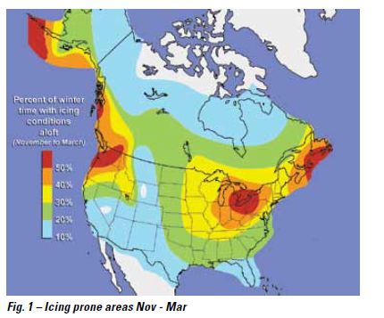
The Great Lakes region also lies in another critical convergence zone where moist air masses from the Gulf meet up with systems moving out of the Rockies, further fueling its massive winter storm potential. And where there is cold air and moisture aloft, there is potential for icing. Fig. 1 illustrates this region’s vast icing potential, evidenced by the hard to-miss red bull’s-eye right over the Great Lakes.
In addition to the local area forecasts, pilots should consider getting a good long range forecast and a big picture of the nation’s frontal activity to help determine what type of weather to expect on a flight. Knowing where the fronts are and where they are moving are key parts to planning a safe flight as well as an exit strategy if needed. Keep in mind also that weather charts only depict frontal boundaries on the surface. The hazardous effects of an encroaching warm front, like super cooled rain can be felt more than 100 miles ahead of what’s depicted on a weather chart.
Oh Yah, It’s Cold - You Betcha
Although somewhat protected by the moisture stripping Rockies to the west, and devoid of any significant natural terrain obstructions, the Great Plains states of the north central United States still have their share of cold weather calamities to deal with. Frigid cold temperatures and blustery winds top the list.
In the same NCDC study mentioned earlier, five of the top 10 coldest cities in the country are in North Dakota and Minnesota, predominantly along the Red River Valley that borders both states. In Fargo, ND, the temperature averages only 9.8 F between December and February. And that doesn’t even take into consideration wind chill factors, an unfortunate byproduct of being in one of the gustiest areas of the United States. Vast open areas can channel Chinook winds from the Rockies with wind speeds occasionally exceeding 100 mph.
“With the amount of strong wind we get, it’s not impossible for us to have wind chill factors of -60 F,” says Jay Flowers, FAASTeam Program Manager and Safety Inspector at the Flight Standards District Office in Fargo, ND. “You won’t fall short of finding a flat place to land in an emergency, but surviving the cold before help arrives is a whole different story.” With the extreme cold conditions in these areas, Flowers recommends pilots are mindful of the proper clothing and survival gear before stepping inside the aircraft. “If there are below-freezing temperatures and any wind at all, survival times can go from hours to mere minutes.”
Flowers also points out another dangerous side effect of high winds: white-out conditions caused by blowing snow. “Icy runways, mixed with blowing snow and stiff crosswinds combine for some pretty risky flying conditions,” says Flowers. To stay connected with conditions at your destination, always have the latest weather data on hand. Flowers also suggest contacting the local airport manager before your flight for an update on any problem areas a weather briefer may not be aware of.
Seattle’s Best (…and Worst)
Washington State may be famous for its coffee, but it’s also well known for its extraordinary ability to produce fog, icing, and every pilot’s favorite—freezing rain. It all starts with the sustained onshore flow of abundant moisture from the Pacific Ocean. Mix in upslope flow along the Cascade Mountains, low level cloud cover, and the freezing levels frequently below Minimum En-route Altitudes (MEA) most of the year, and you have one the country’s most reliable areas for visibility restrictions and icing hazards.
“The Washington Cascades are a veritable icing factory,” says National Weather Service (NWS) Meteorologist Allen Kam, who’s spent the last 20 years preparing public, aviation, and marine forecasts at the Seattle National Weather Service Forecast Office. “Low level westerly flow that develops behind a frontal system and impacts the north-south oriented Cascade mountain range can frequently get up to 40 to 60 knots.” says Kam. “The upslope flow caused by those strong winds flowing up over the Cascades can translate to some pretty severe icing conditions.” The reliability of icing conditions is a big reason why the Cascades are a popular location to conduct aircraft icing certification tests.
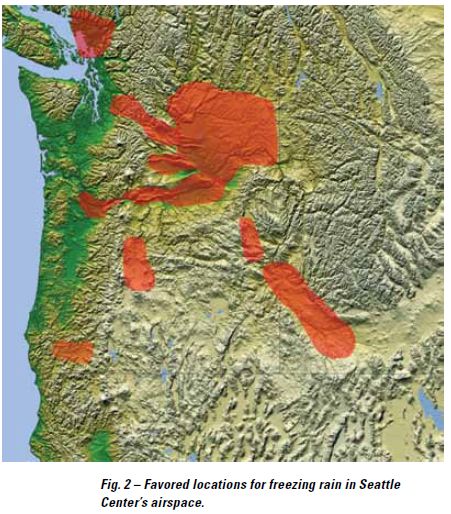
Freezing rain is another nemesis for pilots in the Pacific Northwest, especially for those trying to fly over eastern Washington, or those trying to avoid the ‘icing factory’ over the Cascades by crossing at lower levels through mountain passes (see Fig. 2). These Cascade passes and the Columbia River Gorge can become a freezing rain trap. The overall freezing level may be above pass level (3000-4000 feet for the Washington Cascades and near sea level for the Columbia Gorge) but still below the MEA levels (7,000 to 12,000 feet) over the Cascades. However, sub-freezing air can collect at the lowest levels near the surface in the passes and the gorge, below the layer of warmer air just above. With that, the stage is set perfectly to allow precipitation falling through the warmer air aloft (just below the main freezing level) to turn into freezing rain in the shallow layer of sub-freezing air near the surface of the passes; right where pilots who are trying to avoid the higher level ‘icing factory’ may be flying.
These sub-freezing liquid rain drops can freeze on impact and cause dangerously rapid ice accretion. Often the best course of action for pilots caught in this predicament would be to attempt an immediate climb to the shallow layer of warmer air just above. Over eastern Washington, cold subfreezing air often collects at the surface and just above in the Columbia Basin (the area between the Cascades and Spokane, Wash. and Pendleton, Ore.). Pacific frontal systems crossing the area often bring a layer of warmer air aloft even across the Cascades. As with the Cascade passes, precipitation falling through that lower level warm air can turn into freezing rain when it hits the sub-freezing air at the surface and can produce dangerous icing conditions.
Although icing and freezing rain might be more common in the winter, the visibility-robbing dangers of fog and low stratus clouds are a more persistent threat. According to the NWS, the foggiest place in the United States (excluding mountaintops) is the aptly named Cape Disappointment at the mouth of Washington’s Columbia River. It averages 106 days of dense fog a year. The nearby area of Willapa Bay was reported as having a whopping 7,613 hours of fog in a year – that’s about 317 days! According to Kam, the peak fog period for the northern Pacific Coast is between November and January, with November being the worst.
Needless to say, it’s best to keep an eye on the temperature/dew point spread, no matter where you fly. Fog and low clouds can form rapidly, turning a VFR pleasure trip into an IFR nightmare in minutes.
To help prevent these types of scenarios from occurring, Kam recommends pilots make more use of the Aviation Forecast Discussion, a blog-like product on the NWS’ website that allows forecasters to explain in plain detail what he/she thinks are the problem areas with the forecast that day. “It provides a more insightful look at what the forecaster’s thought processes are and allows pilots to ‘read between the lines’ about why certain events can be expected,” says Kam.
Fearsomely Foul Foes
Weathering the extremes of northern U.S. climates can be a challenging prospect for any pilot. However, once you begin to unlock the mystery behind where and why these conditions occur, you’ll soon see the fog lift and reveal a path to safer weather strategies.
Learn More
GA Pilot’s Guide to Preflight Planning, Weather Self-Briefings, and Weather Decision Making
https://www.faasafety.gov/files/gslac/courses/content/33/346/GA%20Weather%20Decision-Making%20Aug06.pdf
AOPA Air Safety Institute Online Course: Air Masses and Fronts
http://flash.aopa.org/asf/wxwise_fronts/wxwise_fronts.cfm?WT.mc_id=120120epilot&WT.mc_sect=sap
A Pilot’s Guide to In flight Icing: NASA
http://aircrafticing.grc.nasa.gov
Tom Hoffmann is associate editor of FAA Safety Briefing. He is a commercial pilot and holds an A&P certificate.
|