New Helicopter Emergency Medical Services
Weather Tool
by Larry Buehler
Reprinted with permission from FAA
Aviation News
A review of the commercial Helicopter
Emergency Medical Services (HEMS) accidents from January 1998 through December
2004 revealed a need for more detailed flight planning. While this study
concerned only HEMS accidents, flight planning information sources are relevant
to every facet of aviation. One of these sources is the Aviation Digital Data
Service (ADDS), which was introduced in 1997 as an experimental digital data
program that would contain weather observations and forecasts important to the
aviation community and would be available via the Internet.
The ADDS has added a new tool to help HEMS
operators make better weather related go/no-go decisions. This system is
currently in the experimental phase and, as such, there are restrictions placed
on its use for flight planning. While The ADDS HEMS Weather Tool is intended for
HEMS operators, it is available to the public and may prove useful for many
other segments of the aviation community.
Every one knows that HEMS operate in a very
demanding environment. They provide an invaluable service to the public by
providing crucial, safe, and efficient transportation of critically ill and
injured patients to medical care facilities. While the contribution of HEMS is
profound as a component of the nation's medical infrastructure, from an
operational standpoint, it is a commercial aviation activity performed by FAA
certificated air carrier operators. Therefore, operations must have the highest
level of safety. HEMS operators are generally certified under Title 14 Code of
Federal Regulations (14 CFR) part 135 as on-demand air carriers. Legally they
operate like a normal charter business even though their role is very different.
The HEMS Weather Summit
In order to prevent controlled flight into terrain (CFIT) and loss of control
(LOC) accidents, the FAA, the HEMS industry, and the University Center for
Atmospheric Research (UCAR) (which is a consortium of universities) conducted a
HEMS Weather Summit in early 2006. One of the conclusions of the summit was that
there was an absence of usable ceiling and visibility data between reporting and
forecasting stations. Often, HEMS operators conduct entire HEMS flights in the
area between such stations, with reliance on off-course stations and area
forecasts to make critical flight planning decisions. One of the outputs of this
summit was a commitment to provide the HEMS operating community access to
information, which might support better weather decision-making in VFR
operations.
Following the weather summit, FAA asked UCAR's Research Applications Laboratory
(RAL) to develop a weather tool as a part of the ADDS experimental Web site.
This weather tool would provide access to 'gridded' ceiling and visibility
assessment in areas between Aviation Routine Weather Report (METAR) and Terminal
Area Forecast (TAF) reporting/forecasting sites. The ceiling and visibility data
are 'assessments,' meaning they are determinations of the ceiling and visibility
that are likely to exist in the grid block based on terrain influences,
technical assessments, and observations provided to software forecasting models
that automatically generate the graphical product. The user must understand that
this weather product is not a report of an observation or a forecast. It is an
assessment of the ceiling and visibility at the time chosen by the user and at
the location of the grid block(s).
In addition, this product has not completed a rigorous Flight Standards
operational suitability assessment. This assessment establishes the product as
either a primary weather product that meets all safety and regulatory
requirements (e.g., METAR or TAF) or as a supplementary weather product for
increased situational awareness. Until that assessment, the product currently is
experimental, but highly informational.
The user should be aware that the weather tool derives ceiling and visibility by
interpolating the nearest METAR data. This interpolation process, in effect,
'stretches' limited-area METAR observations across a broader area between
stations accounting for terrain effects on ceiling height. The results are the
likely conditions between METAR stations. However, a critical issue is that the
reliability of the information generally degrades as distance from a METAR site
increases. Thus, users should apply practical judgment when considering the
'likely' weather conditions that are remote from a METAR site. To aid in this
judgment, the product provides confidence fields that integrate a variety of
product quality factors. Accordingly, indications of a 'likely' weather
condition that indicates a no-go condition should strongly influence the
decisions of certificate holders authorized to use this product.
The ADDS HEMS Weather Tool allows the user to
identify gridded weather assessments in 5 km by 5 km blocks. The weather data
available includes flight category, ceiling, visibility, radar, convection,
icing, temperature, relative humidity, and wind. Overlays on the graphical data
include wind barbs, METARs, PIREPs, AIRMETs/ SIGMETs, TAFs, VORs, state and
county boundaries, and a base map of terrain and cultural information.
This data became available November 1, 2006, on the ADDS website
at https://www.aviationweather.gov/hemst. The site contains a tutorial as well as 'frequently
asked questions.' In addition, you can find a technical report on the
performance of this weather tool at www.avmet.com
under the 'Supplementary Weather Products' menu. Taking the tutorial and
reviewing the report will help users understand how to use the tool most
effectively.
There are some limitations, however. Operators
may not use this weather tool in any way to support IFR operations. The only
approved use of this weather tool is in VFR operations, and then only in the
context of supporting a 'no-go' decision. Operators may not use the HEMS Weather
Tool as the sole source for decisions to 'Go.' They may only use established
primary products, such as METARs, TAFs, area forecasts, weather depiction
charts, prognosis charts, etc., to make both 'Go' and 'No-Go' decisions. Here
are a few examples:
- If primary products, such as METARs, TAFs,
and area forecasts, indicate a proposed flight would encounter weather
conditions worse than those required by Operations Specification (also known
as Op Spec, which is a set or rules or guidelines that apply to part 135 and
121 operators) for VFR operations, and the HEMS Weather Tool indicates that
conditions meet Op Specs minima, an operator cannot use the HEMS Weather
Tool to support a 'Go' decision not supported by primary products.
- If the primary products indicate that an
operator could complete a flight in conditions at or above the OpSpec
minima, and the HEMS Weather Tool indicated weather lower than required
along the route of flight, the HEMS Weather Tool can support a 'no-go'
decision. This is particularly important since many primary products (such
as area forecasts) do not have the specificity to identify highly localized
low weather conditions. The HEMS Weather Tool can resolve assessments at the
5km by 5km grid level.
The following table reflects the relationship of the HEMS Experimental Weather
Tool to primary weather products:
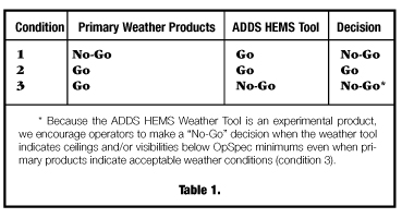
In cases where the weather tool supports an initial 'No-Go' decision, depending
on the extent of the area of assessed low ceilings and/or visibilities, it may
also provide information which would support re-routing a flight to avoid
indicated hazardous ceiling and visibility conditions. In these cases, the
primary products, as well as the ADDS HEMS Weather Tool would then both indicate
acceptable conditions along the re-routed flight path, meeting the criteria of
condition 2 in Table 1.
In some cases, a certificate holder may choose to disregard the ADDS HEMS Tool
on the basis of direct observations, pilot reports, or other data. However,
should the certificate holder elect to operate when the weather tool indicates
unacceptable conditions, knowledge of the weather tool's assessment may increase
the pilot's situational awareness and support more timely in-flight decisions to
divert or land short if the pilot observes deteriorating conditions in-flight.
Delaying such in-flight decisions substantially increases the potential for
inadvertent instrument meteorological conditions (IMC) encounters, with the
resulting increased risk of a CFIT or LOC accident.
HEMS part 135 certificate holders are encouraged to consider adopting this HEMS
Weather Tool into their approved weather program under Operations Spec A010,
Aeronautical Weather Data. To obtain approval to use the ADDS HEMS Weather Tool,
the certificate holder must provide access to the ADDS HEMS weather tool
tutorial and the technical performance report to pilots and other personnel,
before using the product. Also pilots and other personnel who will use the ADDS
HEMS Weather Tool must review these documents.
After reviewing this documentation and establishing the method to accomplish the
training, the Part 135 certificate holder may request authorization to use the
ADDS HEMS Weather Tool to support VFR flight operations under their OPSpecs.
This authorization is accomplished by amending existing OpSpec paragraph A010
through coordination with your Principal Operations Inspector.
After using this weather tool briefly, it is my opinion that it is a major step
forward in the presentation of weather information. In the future this HEMS
Weather Tool could serve as the basis for a larger scale general aviation
version that would be very useful in VFR planning and enhancing situational
awareness. Like HEMS opera'tors, GA pilots often fly to areas that lack
weather-reporting systems. The system also can provide a good overview of
possible conditions likely to be encountered along routes with limited reporting
points. This visual display allows pilots to rapidly ascertain the likely
weather situation at all points along the flight. By presenting the information
in graphical form a pilot can clearly see a line where marginal conditions start
and how far they might continue. This could help prevent pilots from trying to
push their luck as conditions deteriorate. This would be useful not only for
HEMS operators, but for any pilot.
As was stated earlier, the HEMS Weather Tool is still experimental and can only
be used in a very limited way. But as a pilot you should check it out. While it
may not be usable directly today, it can provide an excellent picture of what
you can expect to see on your flight. In many cases it could be the only way to
get any weather information for the area you're headed to. I think this weather
tool could be very useful. Now it's your turn to try it and tell us what you
think.
The main source of information on this new ADDS tool is a notice to aviation
safety inspectors concerning its use and implementation (Notice N8000.333).
Questions, comments, and other feedback concerning this tool may be directed to
the Flight Standards Service, Commuter, On Demand, and Training Center Branch,
AFS-250, at
(202) 267-8166.
Larry Buehler is an aviation safety inspector
with the Air Transportation Division's Commuter, On-Demand, and Training Center
Branch in Flight Standards Service.
|